The Late Carboniferous is when Pangea was first formed in Earth’s history. Pangea is the most recent supercontinent, a land state where the dry land on Earth is all collected in a singular mass. There have been more than one of these, yet, Pangea was the last.
This variation of Pangea, Siberia, China, and the Western portion of the United States are not yet directly connected. However, these all would become fully connected in the late Triassic. As what goes up must come down, the supercontinent of Pangea started to break apart during the Jurassic. By the late Jurassic, the Atlantic Ocean began to open up. Africa and South America, still connected, started to separate from North America.
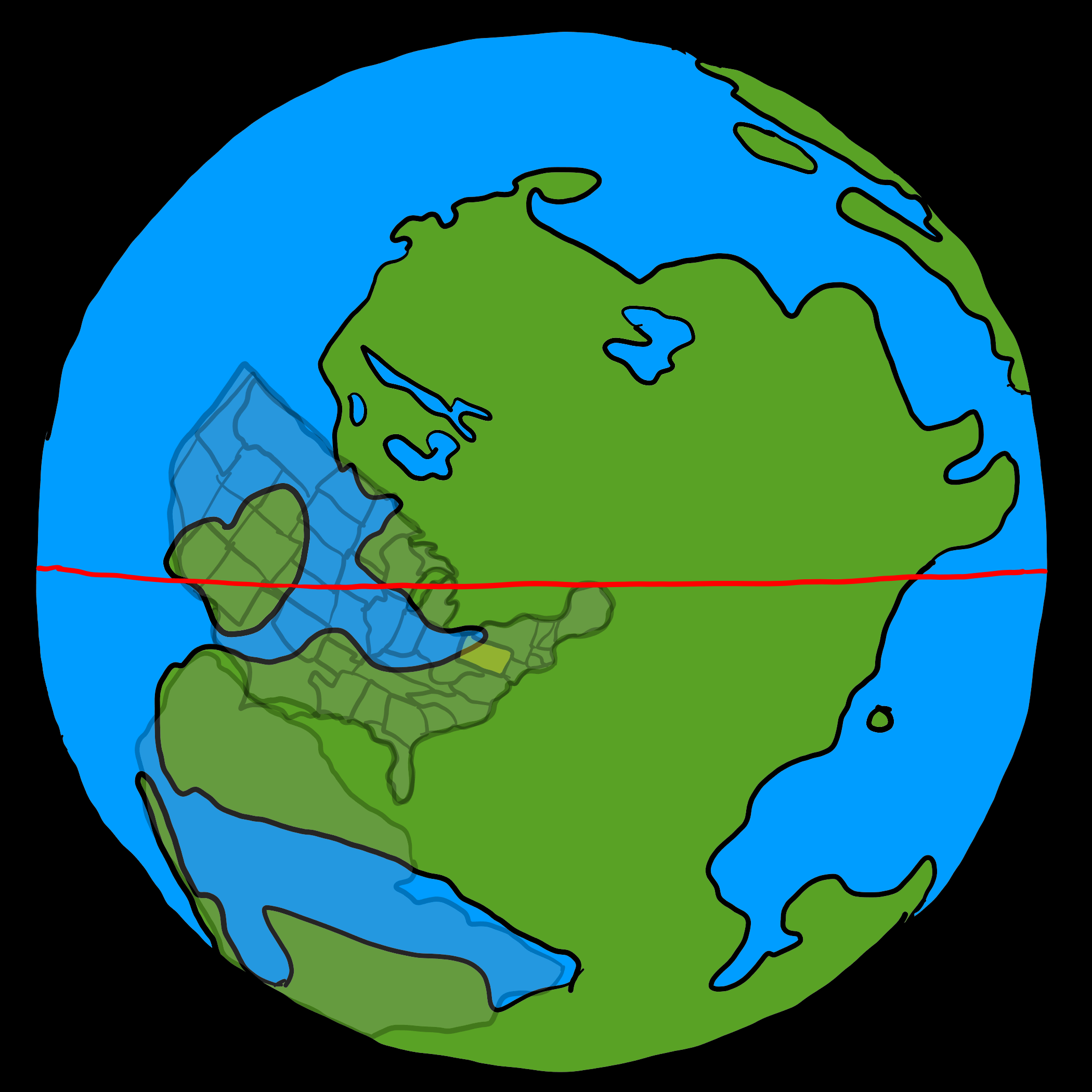
Parks Township, 300 Million Years Ago
The map below shows the Earth 300 million years in the past. How can we know this for sure? The truth is, we don’t. But with lots of scientific work in the field of Paleomagnetism, very dedicated people have made some well-researched predictions. Keep in mind this field is still young. Literal map-changing discoveries happen often. While researching this topic, I found several conflicting maps.

The heart of Paleomagnetism involves making measurements of magnetic field alignments in dated rock beds. When lava forms, a magnetic field direction becomes locked in as it cools. Scientists in the field then collect, date, and measure the magnetic field direction. Upon determining the direction, the scientist deduces a position and records it.
It can be a difficult concept to grasp or even believe. Not widely accepted until the early 1960s, Plate tectonics, or more specifically continental drift had been seriously researched for 50 years prior. The idea of continental drift was first proposed in 1596 by Abraham Ortelius. Several people developed the theory further, but it wasn’t researched thoroughly until Alfred Wegener published his article about it in 1912.
Research involving measurements of rocks from both sides of the ocean—along with exact fossil record matches—helps formulate and push the theory. Today, an extra 2.5 centimeters is added to the Atlantic ocean every passing year. North America and Africa are moving in opposite directions relative to each other.
Alfred Wegener

Born in 1880, Alfred Wegener is one the most influential figures in the current understanding of global geology. While continental drift was proposed as a theory long before his birth, his works on it for the 18 years until his death helped develop a widely accepted, fully developed theory. If you were to tell someone in 1900 that Parks Township used to be a tropical location below the Earth’s equator, the vast majority of people and experts in the field of Geology would tell you that you were wrong.
His ideas were not accepted because of a misunderstanding that the continents were supposed to fit along the exposed coastlines. Wegener was considering the continental shelves, which are currently around 200m below the current shorelines. Also, he believed the motion was as high as 250 cm/year. It turned out that the actual spread in the Atlantic is 2.5 cm/year.
In the 1950s, the science of paleomagnetism helped prove much of the data in Wegener’s theory. In the 1960s, seafloor spreading was also discovered, which brought it further along. Ultimately the theory helped develop the theory of plate tectonics, which show that plates over the entire Earth are in motion.
Wegener died doing what he was passionate about. At 50, it was believed he died of heart failure while on an expedition in Greenland. Rasmus Villumsen, 23 years of age, was the only one with him when he died, and it is believed he took Wegener’s journal with him after burying him. However, he also did not survive, and it’s thought that his body is somewhere buried under hundreds of feet of snow and ice.
Climate and Geography in a Carboniferous World
The climate is another significant factor in determining what it was like in a world so long ago. In the Carboniferous specifically, the Earth was awash with Oxygen, and the sea level changed frequently. For example, 323 million years ago, seas were shallow. Where was the water? Locked up as ice in the North and South poles. This exposed landmasses and created wet swamps in low areas.
In Parks Township specifically, the Glenshaw Formation has several distinct limestone layers. Ancient seas moved inland during climate changes. This climate is why the limestone layers formed. On a hillside, over 60 feet of elevation, you can find marine sea life fossils and land plants. Towering Lepidodendron trees were abundant at times. Five hundred thousand years later, you could see giant cephalopods such as Solenocheilus swimming in a local shallow saltwater environment.
Another dimension to consider is geography. The mountains, seas, and land placement were much different than today. For example, while the Sahara desert lies near the same latitude as Guatemala, an arid desert dominates the landscape. Guatemala gets the same amount of sun, but the Sahara doesn’t have moist ocean air to create a tropical landscape as you’ll find in Guatemala.
The Appalachian Mountains
Parks Townships rests within the Appalachian Plateau. The plateau consists of uplifted land caused by the formation of the Appalachian Mountains. These mountains were formed 480 million years ago and existed at the center of Pangea. As North America and Africa rush away from each other in the present day, they once were moving toward each other. The immense pressures and forces created as two continents collide create great mountain ranges and uplift. The mountain range was as impressive as the current-day Rocky Mountains. However, erosion has reduced their once great stature.
Carboniferous rainforest collapse
Around 305 million years ago, this collapse marked the start of the end of the Carboniferous. On land, vast rainforests changed over to islands of vegetation, each housing unique species depending on size and location. These events also affected the oceans of the world, starting a decline in diversity.
References
This is a short list of references. I have more to collect.
- Research Website of Christopher R. Scotese
- PBS Eons – When the Rainforests Collapsed
- Alfred Wegener – Article on Wikipedia
- Wheeler-Dubias, M., #bioPGH Blog: Pennsylvania of Yesteryear