Parks Township comprises of three different geological formations. At the lowest points and at the Kiskiminetas River, you’ll find the Allegheny Formation. Next, the majority of township land is considered to be the Glenshaw Formation. Lastly, the highest hilltops contain the Casselman Formation.
Generalized Parks Township Formation Geology Illustration
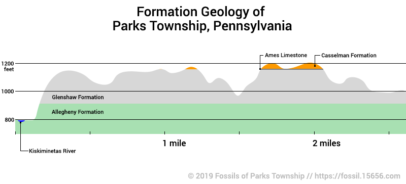
Generalized Formation Geology of Parks Township
by John A. Harper 2019
In learning about local geology and formations, it can be confusing to visualize how the formations lie. The map above is an attempt to do that. My original map had flat formations but an expert in state geology provided a better version for me. While sedimentary rocks typically form in water, the terrain varies. Erosion is one factor, generally being responsible for all the dips in the terrain of the map. Another is the flow of water over time, where meandering rivers and streams can erode or deposit different thicknesses of material over millions of years.
The dips in the formations are due to local synclines and anticlines. These are folds in the local formations that have them rising and dipping. You can not find a rock outcrop at 900 feet, and expect it to be the same a few miles down the road at the same elevation.
Most of the exposed sediment was laid in Parks Township during the Carboniferous, which ended 298 million years ago. As the underlying lands were left dry and the seas retreated, the land started to erode. I am not sure how high the land may have once been, I don’t believe there is any research that has defined erosion rates. That is why you won’t find rocks with dinosaurs anywhere near Parks, there wasn’t any new land being laid down during the age of the dinosaurs, 252 million to 66 million years ago.
All of the township and the county are part of the greater Allegheny Plateau. This plateau is known as a dissected plateau, whereas portions appear mountainous. As the land rises, the water flows increase, and this faster-moving water cuts deep channels and valleys into the land. The local hills can be very steep and mountainous in appearance. The further East you travel, they appear as true mountain elevations. A famous example of a directed plateau is the Grand Canyon, it is a mile deep but is only 5-6 million years in age, due to uplift that is occurring but at a much higher rate.
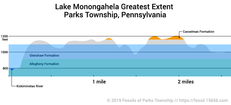
The Ice Ages
Another consideration is glaciation during the ice ages. While glaciers did not advance down to Parks Township, they did cause massive floods that would have drowned all but the hilltops of Parks. Lake Monongahela is one such lake. It was a pro-glacial lake that flooded the terrain to a height of roughly 1,100 feet above sea level.
References and Further Information
- Lake Monongahela – Article on Wikipedia
- Anticlines and Synclines – Geologic Structures Part 5, Radford University