As I learn about the fossils in the local area, I also come across some interesting research articles along the way.
First North American species of the European genus Archaemegaptilus from the Upper Carboniferous Pottsville Formation of northern Alabama (Palaeodictyoptera: Archaemegaptilidae)
The first example of an insect found in Europe, now found in North America. This example comes from the Pottsville Formation, which can be found in Western Pennsylvania below the Allegheny Formation. The formation is correlated and available in Bibb County, Alabama. This is within North Central Alabama.
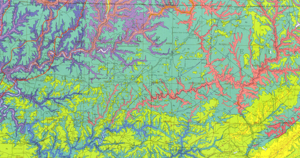
One thing I have yet to find for sure is an insect fossil, aside from small trilobites. The Pottsville formation can be found further North of me, in the deeper river valleys of Armstrong County. It is rather extensive in counties such as Forest, Elk and Venango.
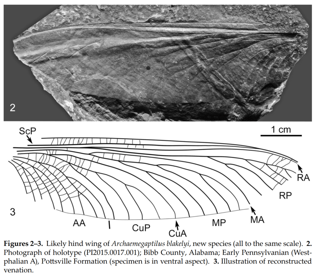
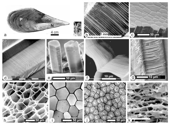
Figures 2-3 from Novitates Paleoentomologicae No 21.
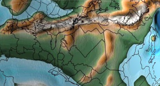
Map showing the Pottsville Formation in Pennsylvania.
The teal color below is the Pottsville Formation in Western PA. Forest County can be seen at top center.
Conservative Evolution in Nautiloid Shell Morphology: Evidence from the Pennsylvanian Nautiloid Metacoceras mcchesneyi from Ohio, USA
Ryoji Wani, Royal H. Mapes, Journal of Paleontology, 84(3):477-492. 2010.
The best part of this article are the spectacular views of cut and polished Metacoceras specimens. There are two presented specimens, OUZC 5706 and OUZC 5716 that were cut and polished along the median plane. These are housed within the Ohio University Zoological Collections. It has inspired me to get one of my specimens cut and polished. It currently is an un-numbered specimen but it will be in the future.
Another interesting insight is that while the septal lines are shown well on the outside of the shell, these were mostly broken/absent once you got inside, at least with these two specimens. These were collected within Columbiana County, Ohio, which is borders Pennsylvania. The limestone / shale marine zone called the Rock Creek Marine Zone exists below the Brush Creek marine zone and above the Upper Freeport Coal within the Glenshaw formation. It is not named the Glenshaw once in Ohio, but it correlates directly with the Glenshaw as named in Pennsylvania.
Geometrid caterpillar in Eocene Baltic amber (Lepidoptera, Geometridae)
Fischer, T.C., Michalski, A. & Hausmann, A. Geometrid caterpillar in Eocene Baltic amber (Lepidoptera, Geometridae). Sci Rep9, 17201 (2019) doi:10.1038/s41598-019-53734-w
A rare preserved caterpillar, Lepidoptera, that normally has little chance of preservation gets studied in a spectacular Baltic Amber find.
Aragonite-calcite transformation based on Pennsylvanian molluscs
UWE Brand
Geological Society of America Bulletin, v. 101, p. 377-390, 13 figs., 3 tables, March 1989.
Department of Geological Sciences, Brock University, St. Catherines, Ontario, Canada L2S 3A1
In this article from 1989, the author talks about the transformation of Aragonite to Calcite in fossil Pennsylvanian molluscs. This came to my attention as I was studying the white Aragonite shell layers that are often found while breaking apart limestone locally. The rocks in question come from Oklahoma, but the geologic processes that maintain Aragonite are discussed. Also, the diagenesis of Limestone is discussed along with the current theories of the time.
Taxonomic validity of Petalodus ohioensis (Chondrichthyes, Petalodontidae) based on a cast of the lost holotype
A cast of the holotype Petalodus ohioensis is found and helps settle a long debate over where the tooth belonged in the Taxonomy of the genus. Finding my own Petalodus tooth helped generate interest in this topic.
What is a holotype?
A holotype is an original specimen that represents a named species. These are physical copies of a species that can be referenced in the future for determining if a specimen is of a particular species.
For Petalodus ohioensis, Safford described the species with a crude drawing back in 1843. The original holotype specimen was lost and the validity of the species was challenged. Based on the crude line drawing itself, what really was a P. ohioensis was confusing to researchers. Somewhat related, a case (3779) was opened within the Bulletin of Zoological Nomenclature to establish a Neotype for the entire Genus. A Neotype is selected when a preexisting Holotype is considered lost.
A resolution from a lost holotype
A cast of the lost holotype (YPM 2861) was found at the Yale Peabody Museum of Natural History in New Haven, Connecticut. In conclusion within the paper, P. alleghaniensis and P. ohioensis are to be considered the same taxa after examining the holotypes.
Current Status of the International Carboniferous time Scale
Barry C. Richards
2013
The Kasimovian stage of the Carboniferous System is what defines the Glenshaw Formation in Parks Township. In North America, the regional stage is known mostly as the Missourian. There are unique stage names for Russia, Western Europe, North America and China. The 3.3 million year length of the Kasimovian stage, part of the Upper Pennsylvanian subsystem corresponds closely to my local formation.
Based on B.C. Richards work, I find that the Ames marine limestone correlates with the end of the Kasimovian stage. I believe the Upper Freeport Coal is the beginning, but I have seen conflicting reports. I’ve also seen the Carboniferous Rain-forest Collapse as occurring at the start of the Kasimovian stage and continued through most of this stage. Since I have yet to find a fossil from a dozen or so feet past my limestone and up, I suspect this collapse has something to do with it.
Coiled Nautiloid Cephalopods from the Brush Creek Limestone (Conemaugh) of Eastern Ohio and Western Pennsylvania
James L. Murphy
Journal of Paleontology, V. 44, No 2. P, 195-205 (March 1970)
Access is closed, article must be purchased.
In this article, the Brush Creek Limestone is represented via a few localities in Beaver and Allegheny Counties, specifically an Ohio river bluff opposite Old Economy park in Ambridge and an abandoned quarry at Wittmer in Alleghey County. Wittmer is a named place on PA Route 8 along Pine Creek and near an area known as Glenshaw, so it fits in well for being within the Glenshaw Formation. It is about 20-25 miles from my collecting sites.
I came looking for information on Metacoceras perelegans, which is what the Metacoceras species I encounter might be. I am unconvinced based on photos showing knobs on both the inside and outside edge, whereas mine seems to only be on the outside.
Predatory behaviour and taphonomy of a Jurassic belemnoid coleoid (Diplobelida, Cephalopoda)
D. Jenny, D. Fuchs, A.I. Arkhipkin, R.B. Hauff, B Fritschi, C. Klug
Scientific Reports 9, Article number: 7944 (2019)
A fascinating article about four separate finds of complete specimens of the cephalopod Clarkeiteuthis conocauda from the Jurassic period, each with a Leptolepis bronni (a bony fish) clasped in its arms. They make the suggestion that the creatures caught the fish, and while consuming their prey, sunk into oxygen depleted water and suffocated.
The article contains 2 impressive figures of specimens (figure 1, figure 2) and a well done artists rendering of what they looked like after grasping the fish.
Clarkeiteuthis conocauda with Leptolepis bronni in its arm crown 
Passaloteuthis bisulcata, as displayed at the Urweltmuseum in Holzmaden, Germany, Toarcian.
Revision of some common Carboniferous genera of North American orthocerid nautiloids
B. KROGER AND R. H. MAPES
Journal of Paleontology · September 2005
In this article, the authors describe how both Mooreoceras and Pseudorthoceras have sort of become garbage taxon in which many different potential species of these straight shelled cephalopods end up being classified. Using six different measurements on more than 1,000 specimens they bring forth new data to help start the discussion of how these should be defined.
I personally have collected a few specimens and it’s usually a simple choice, its either Mooreoceras or Pseudorthoceras. I am not sure of an exact species for either.
Pennsylvanian Pteriomorphian bivalves from the Piaui Formation, Parnaiba Basin, Brazil
By Luiz E. Anelli, Maccello Guimaraes Simoes, Antonio Carlos Rocha-Campos
Journal of Paleontology – November 2006
In this article, Luiz et al. describe a number of species of autobranch bivalves. What brought me to this paper was the search for a mystery fossil that turned out to be a sea pen.
While Northern Brazil and Pennsylvania are generally 3,700 miles apart today, they were moderately closer 300-320 million years ago. Based on Paleogeograpic Maps by C.R. Scotese, Western Pennsylvania and Northern Brazil were both on ocean shorelines on opposite ends of Pangea. While Pennsylvania existed closer to the Equator (Fig 1, thin white line on top), they both produced similar marine fossil species.
Screenshot from the Dinosaur Database
The Prismatic Layer of Pinna: A Showcase of Methodological Problems and Preconceived Hypotheses
By Yannicke Dauphin, Alain Brunelle, Kadda Medjoubi, Andrea Somogyi and Jean-Pierre Cuif
Minerals – Volume 8, Issue 9
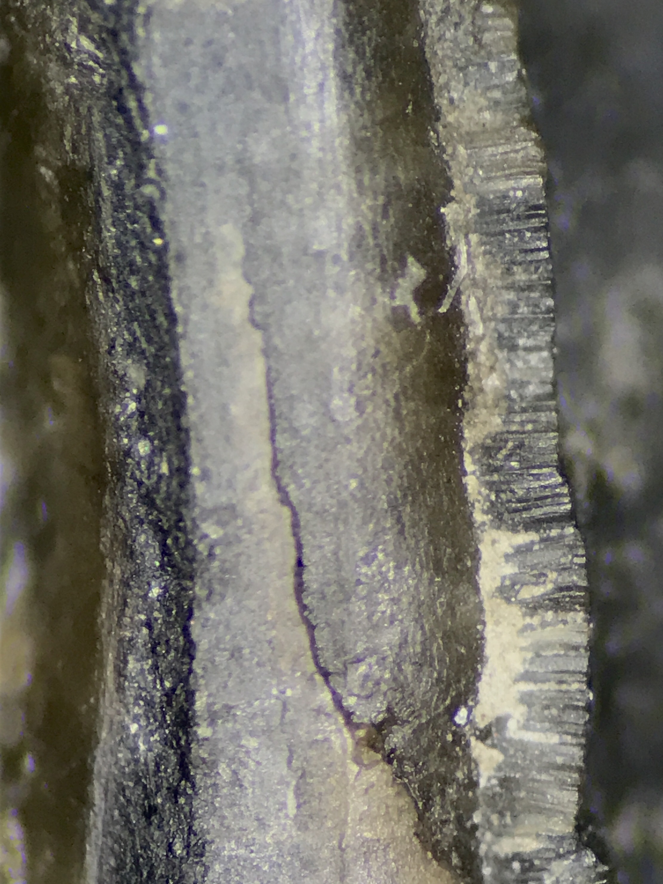
Further research into Sea Pens brought me to this article. In my mystery sea pen, I photographed the micro-structure of the tube running up the middle of my specimen. I found that Figure 2 in the article showed these structures in greater detail. I believe however that the studied specimens in the article were modern Sea Pens.
New Marine Horizon in the Conemaugh Formation
BY J. J. BURKE
SCIENCE 08 AUG 1958 : 302
In this article, Burke described newly recognized marine shale in the Conemaugh formation within the Kiskiminetas Valley. One in particular is the Carnahan Run shale, which is located in Parks township. I believe this shale is too low in the strata to be what I am used to finding, however a quick glance at Google maps shows the elevation is about the same as what I am used to finding locally.
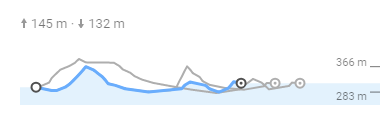
Burke goes on to describe the shale to be a marine shale of 1 1/2 foot in thickness near a road cut on PA State Route Alternative 66. The Ames Limestone is supposed to outcrop 126 feet above the shale in this section. Locally I have attempted to pace a hill that rises 160 feet, again, according to Google, above the Hard Limestone layer I have found locally and I could not locate an additional limestone later, particularly the Ames layer.
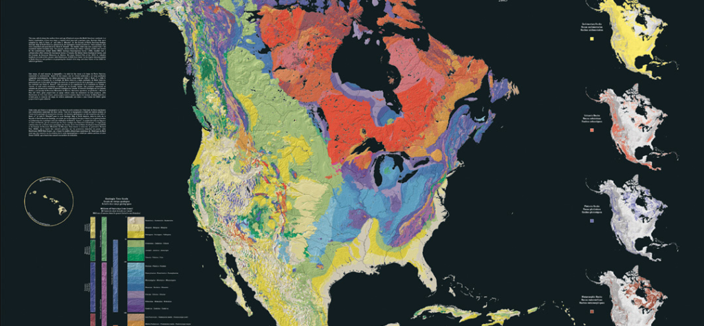
The North America Tapestry of Time and Terrain
A 1:8,000,000,000 scale map of North America showcasing the age of bedrock throughout the continent.
Common Fossils of Pennsylvania
by Commonwealth of Pennsylvania Department of Conservation and Natural Resources and the Bureau of Topographic and Geologic Survey
The Fantastically Strange Origin of Most Coal on Earth
by National Geographic